

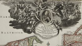
1780 – F. L. Güssefeld – Borussiae Occidentalis Tabula
150 €
Title: “Borussiae Occidentalis Tabula…”
Description:
Very detailed map of western Prussia, showing the capital city of Danzig, after D. D. Büsching’s map of the region. Inset map shows Emland with the cities of Elbing and Braunsberg.
The map was designed by Franz Ludwig Güssefeld and published by the Nuremberg’s publishing house Homann Erben in 1780.
Cartographer: Franz Ludwig Güssefeld
Sheet size: 63,6 x 53,3 cm
Year: 1780
Technique: copper engraving
Condition:
Good condition. Few worm holes in margin. Watermarked paper.
This is an original antique map published in 1780 and NOT a modern copy or reprint
On your request I will provide a Certificate of Authenticity
In stock


")


