1795 – J. Nieprecki – Magnus Ducatus Lituaniae
850 €
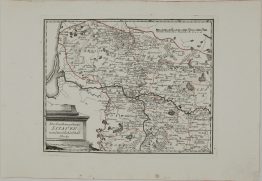
Title: “Magnus Ducatus Lituaniae in suos Palatinatus et Districtus Divisus. delineatus a Rever Patre Ioanne Nieprecki Soc. Jesu Simuluque exactiore locarum positione quantum fiere potuit correctus a Tobias Majero . . .”
Description:
Rare map of Lithuania and part of Latvia, Poland and Belarus compiled by the Tobias Mayer. The map was published by the firm of Homann Heirs, the leading German map publisher of the 18th century founded by Imperial Geographer Johann Baptist Homann. Mayer based the map on cartography by the Warsaw based Jesuit Missionary Jan Nieprecki who heavily relied on the the famous 1603 map by the Lithuanian statesman and cartographer Mikolaj Krzysztof Radziwill. Handsome title cartouche which is topped with the Arms of Lithuania featuring the Vytis or White Knight, first used as a state symbol in 1366. The fourth state.
Cartographer: Jan Nieprecki (1719-1754)
Sheet size: 55,1 x 49,4 cm
Year: 1795
Technique: copper engraving
Condition:
Good condition. Original hand coloring. Narrow margins. Strong press on watermarked paper, lightly age toned.
This is an original antique map published in 1795 and NOT a modern copy or reprint
On your request I will provide a Certificate of Authenticity
In stock