1749 – J. T. Mayer – Magnae Britanniae
250 €
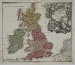
Title: “Regnorum Magnae Britanniae et Hiberniae Mappa Geographica iuxta Observationes Astronomicas recentiores denuo correcta et ad formam legitimae projectionis reducta a Tobia Majero”
&
“A General Map of Great Britain and Ireland with Part of Holland, Flandres, France &c. Agreable to Modern History, by the Heirs of late Mr Homann, at Nuremberg 1749. Priviledged by Emperour’s Majesty.”
Description:
Detailed map of the British Isles, extending east to take in the adjoining coasts of Holland, Flanders and northern France. England, Wales, Scotland and Ireland are outlined in hand colour, with Scotland’s shires further divided in red. A separate inset at upper right shows the Shetland Islands at the same scale as the main map, while the Orkneys appear in their correct position off the north coast of Scotland. The map is headed by a large cartouche enclosing the royal coat of arms, military trophies, navigational instruments and a sea monster rising from the waves. Three graphic scale bars — English statute miles, French leagues and German miles — appear at lower right.
This edition is drawn on the astronomical corrections of Tobias Mayer and is notable for its added English-language title, suggesting it was prepared with English buyers specifically in mind. The sheet retains its original atlas page number (“42”) at upper right, confirming it was issued bound into a larger Homann Heirs atlas.
The map drawn by Johann Tobias Mayer and published by Homann Heirs in atlas “Maior Atlas Scholasticus ex Triginta Sex Generalibus et Specialibus…” Nuremberg, 1749.
Cartographer: Johann Tobias Mayer (1723-1762) — German astronomer and cartographer, employed by the Homann Heirs in Nuremberg from 1746 to 1751, credited on the plate with correcting the map to recent astronomical observations
Publisher: Homann Heirs (Homann Erben)
Sheet size: 63,6 x 53,8 cm
Year: 1749
Technique: copper engraving
Condition:
Good condition. Contemporary coloring, paper with watermark.
This is an original antique map published in 1749 and NOT a modern copy or reprint
On your request I will provide a Certificate of Authenticity
In stock