1794 – F. Müller & C. Schütz – Neueste Karte von Polen und Litauen
2,500 €
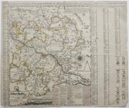
Title: “Neueste Karte von Polen und Litauen samt den Oesterreichischen, Russischen und Preussischen Antheile und den übrigen angraenzenden Laendern. Ao. 1794”
“Carte Générale, et nouvelle de toute la Pologne, du grand Duché de Lithuanie, et des Pais Limitrofes.”
Description:
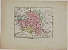
A large and rare map of the Polish-Lithuanian Commonwealth in its last years, published in Vienna by Artaria & Company in 1794. The title’s “Austrian, Russian and Prussian shares” are the lands the three neighboring powers had taken from the Commonwealth in the partitions of 1772 and 1793. The map appeared in the year of the Kościuszko Uprising, the last attempt to save the state. A year later the Third Partition of 1795 removed it from the map altogether.
The map was made to show who held what. A key in German below the map, repeated in French above it, explains the colours:
- Yellow: Poland
- Red: Austria
- Blue: Russia
- Green: Prussia
- Orange: Saxony
- Violet: the Duchy of Courland
The map covers Pomerania, Silesia and Bohemia in the west to Smolensk, Mogilev and Kiev in the east, and Courland and Livonia in the north to Galicia, Hungary and Moldavia in the south. “Litauen” is written in large letters across the Grand Duchy, which is shown with its voivodeships, towns and rivers, as well as forests and the vast Pinsk marshes (“Rokitno Moraste”). A key below the map explains the symbols for fortresses and towns of different sizes, beside scale bars for several kinds of mile.
The decorative title cartouche in the upper left shows putti drawing back a curtain and holding up the arms of the Commonwealth. The arms combine the White Eagle of Poland and the Vytis of Lithuania, with the bull of the Ciołek arms at the centre. Ciołek was the family coat of arms of Stanisław August Poniatowski, the last King of Poland and Grand Duke of Lithuania.
Carl Schütz (1745–1800), the Viennese architect, painter and engraver, designed and engraved the cartouche. Franz Müller (1755–1816) engraved the map (“F. Müller fecit in Wien”). It was published with an imperial privilege (“C. Priv. S. C. M.”) and sold by “Artaria & Compagnie, Kunsthändlern auf dem Kohlmarkt”. Artaria was one of Vienna’s leading art and music publishers and also published Haydn and Mozart. The plate was engraved around 1790 and reissued several times, with the date and borders updated as the partitions changed the map.
Map Maker: Carl Schütz (1745–1800) & Franz Müller (1755–1816)
Publisher: Artaria & Comp., Vienna
Sheet size: 76,5 x 54,5 cm
Technique: copper engraving
Year: 1794
Condition:
Good condition. Watermarked paper. Professionally cleaned and reinforced wit Japanese tissue on verso. Contemporary hand colouring.
This is an original antique map published in 1794 and not a modern copy or reprint
On your request I will provide a Certificate of Authenticity
In stock