c. 1720 – J. B. Homann – Orlog oder Kriegs-Schiff
750 €
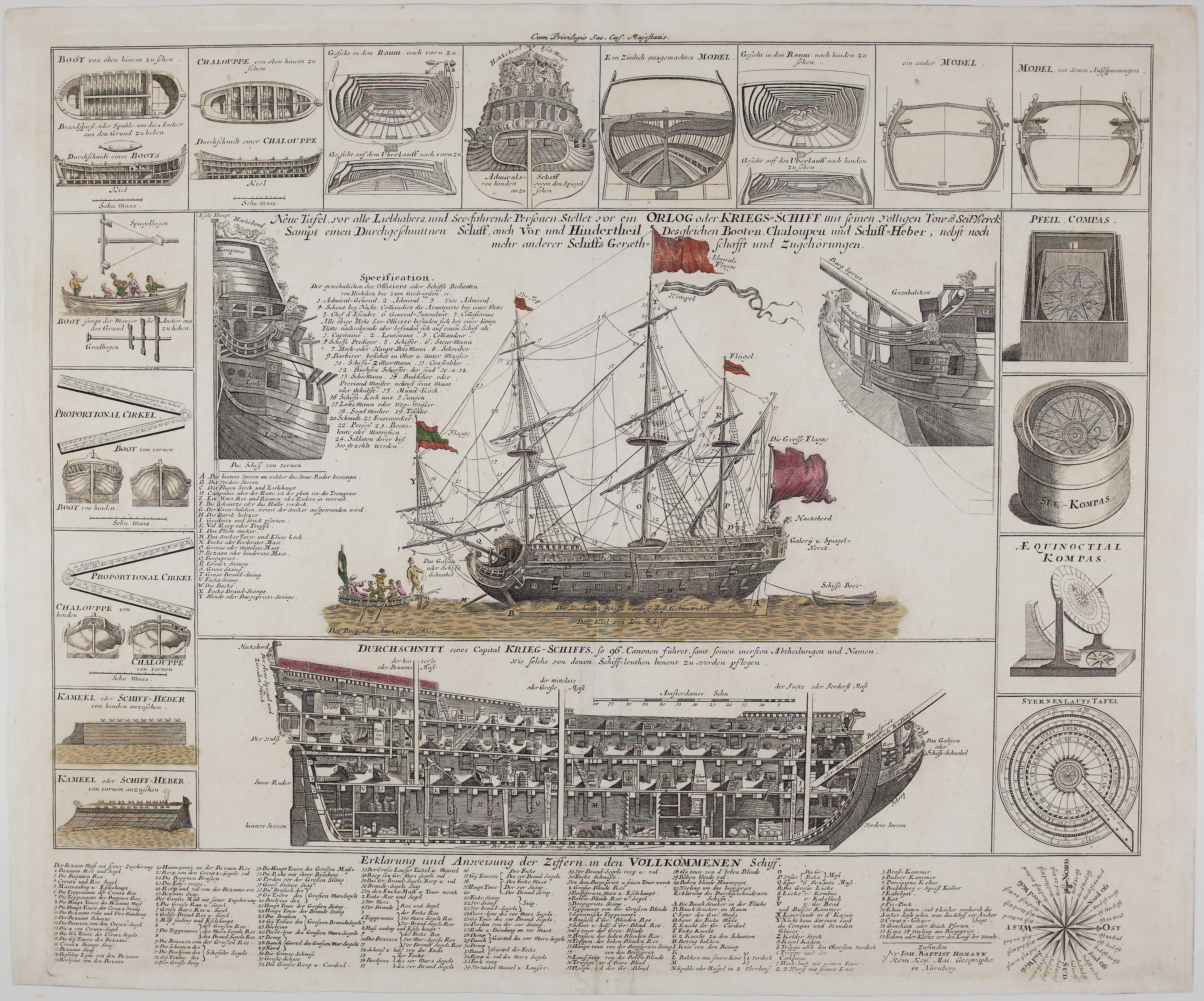
Title: “Neue Tafel vor alle Liebhabere und See fahrende Personen Stellet vor ein ORLOG oder KRIEGS SCHIFF mit seinen Volligen Tour & Seil Werck Sampt einen Durchgeschnittnen Schiff auch Vor und Hinder-Theil Desgleichen Booten Chaloupen und Schiff-Heber, nebst noch mehr anderer Schiffs Geräthschaffti und Zugehörungen.”
Description:
A large, richly detailed copper engraving by Johann Baptist Homann depicting a 96-gun ship-of-the-line (Orlog, from the Dutch “oorlog,” war) in full rig at anchor, with a lengthwise cross-section below showing the vessel’s interior decks and compartments, each named as sailors of the period would have called them. Surrounding the central image are 17 subsidiary views and diagrams: construction details of a ship’s hull and a chaloupe seen from above and in cross-section, a stern ornament (“Hackebord”) and bow/figurehead detail, two styles of finished hull model, navigational instruments including a backstaff (“Spiegelbogen”), proportional dividers, a mariner’s compass, an equinoctial compass, and a star-course table, plus two views of a “Kameel” or ship-camel — the inflatable/buoyant pontoon device used to lift heavy-draft ships over shallows. A specification panel lists the full hierarchy of a warship’s crew, from Admiral-General down to ship’s boys, and an extensive nine-column key at the foot identifies every numbered line, stay, and sail on the main ship by name. The sheet is headed “Cum Privilegio Sac. Caes. Majestatis” — the imperial printing privilege — which places this impression after the plate’s earliest state, since the first edition (per Sandler’s standard Homann bibliography) was issued without it.
Johann Baptist Homann, appointed Imperial Geographer in 1715, was the most prominent German map and print publisher of the early 18th century; this plate was occasionally bound into atlas, but circulated mainly as a separate decorative sheet, and surviving examples are notably less common than his regional maps.
The engraving comes from the atlas “Atlas novus terrarum orbis imperia regna et status exactis tabulis geographice demonstrans…“ published in Nuremberg circa 1720.
Engraver: Johann Baptist Homann (1664-1724)
Sheet size: 61,5 x 51,0 cm
Year: c. 1720
Technique: copper engraving
Condition:
Good condition. Watermarked paper.
This is an original antique engraving published circa 1720 and NOT a modern copy or reprint
On your request I will provide a Certificate of Authenticity
In stock