1726 – R. & J. Ottens – Ducatus Pomeraniae
300 €
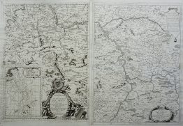
Title: “Ducatus Pomeraniae Tabula Generalis in qua sunt Ducatus Pomeraniae, Stettinensis Cassubiae Vandalliae et Bardensis Principatus Rugiae ac Insulae, Comitatus Guskovensis et Dominia Louwenburgense Wolgastense et Butoviense per Fredericum de Wit Cum Privilegio ex Officina R. I. Ottens Amst.”
Description:
Rare antique map of the Duchy of Pomerania along with adjacent regions spanning modern-day northeastern Germany and northwestern Poland, after Frederick de Wit map. It borders the Baltic Sea, labeled here in Latin as Mare Balticum and in Dutch/German variations as Vulgo De Oost Zee. Very decorative title cartouche.
The geographical layout was originally created and engraved by the Dutch cartographer Justus Danckerts in Amsterdam. Following the decline of the Danckerts firm, the Ottens brothers acquired their inventory of printing plates in 1726. They modified the cartouche at the top to display their own imprint—”Authore per R. & J. Ottens”—and sold it inside their own commercial atlase “Atlas Maior” published in Amsterdam.
Cartographer: Renier Ottens (1698–1750) & Joshua Ottens (1704–1765)
Sheet size: 64,3 x 54,1 cm
Year: 1726
Technique: copper engraving
Condition:
Very good, original condition. Contemporary outline coloring.
This is an original antique map published in 1726 and not a modern copy or reprint
On your request I will provide a Certificate of Authenticity
In stock