1756 – Le Rouge – Grand Duche de Lithuanie
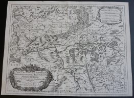
Title: “Grand Duché de Lithuanie Divisé en 9 Palatinatis”
Description:
Rare map of the Grand Duchy of Lithuania at the height of its division into nine palatinates. Covers the region from the Baltic coast at Memel and Libau, north through Courland and Livonia to Riga, east across the Daugava and Dnieper to Smolensk on the Russian frontier, and south to Grodno, Pinsk and the Polesie marshes. Rivers, forests, and scores of towns and villages are named throughout.
The map comes from Georges-Louis Le Rouge atlas “Atlas Nouveau Portatif” issued in Paris, 1756.
Cartographer: Georges-Louis Le Rouge (17121 – 1790)
Sheet size: 34,0 x 23,2 cm
Year: 1756
Technique: copper engraving
Condition:
Very good condition. Strong press on watermarked paper, contemporary coloring.
This is an original antique map published in 1756 and NOT a modern copy or reprint
On your request I will provide a Certificate of Authenticity