1702 – H. Scherer – Regionum Circum Polarium
500 €
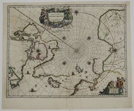
Title: “Regionum Circum Polarium Lapponiae Islandiae et Groenlandiae Novae et Veteris Nova Descriptio Geographica 1701.”
Description:
Rare antique map focused on the North Pole and Arctic regions, including Scandinavia, Iceland, Greenland, northern parts of North America and Northern Canada. It is famously embellished with numerous engraved scenes depicting life and exploration in the North. Scenes include the whale hunts, bear hunting, and reindeer. Indigenous figures engaged in trading, specifically a “Lapland market” scene in the bottom right corner. The map also features a central polar projection with banners at the top reading “Solem adorant, & Deum, qui fecit solem” (They adore the sun, and God, who made the sun).The sea monsters and the mythical island of “Frisland” shown too. Verso antique hand drawing sketch of the monk.
Published by Heinrich Scherer in atlas “Atlas Novus…”, Munich, 1702.
Cartographer: Heinrich Scherer (1628–1704)
Sheet size: 35,2 x 23,5 cm
Year: 1702
Technique: copper engraving
Condition:
Good condition. Narrow margins.
This is an original antique map published in 1702 and not a modern copy or reprint
On your request I will provide a Certificate of Authenticity
In stock