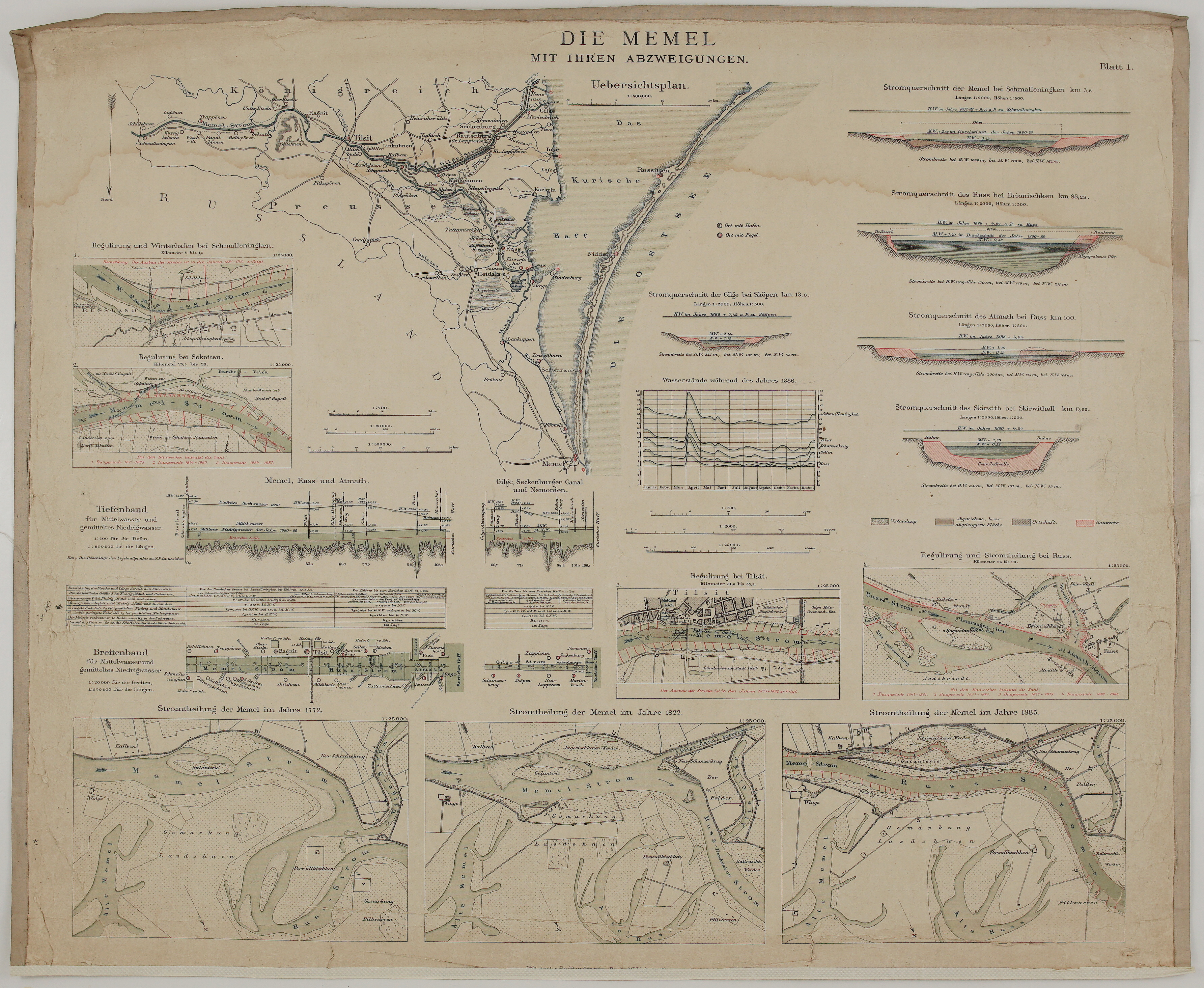
1891 – Die Memel mit ihren Abzweigungen
250 €
Title: “Die Memel mit ihren Abzweigungen. Blatt 1.”
&
“Uebersichtsplan” … “Lith. Anst. v. Bogdan Gisevius, Berlin”
Description:
large and detailed engineering sheet on the lower Memel (Neman), the great river of Lithuania. It is sheet 1 of the atlas “Die Ströme Memel, Weichsel, Oder, Elbe, Weser und Rhein und die Märkischen Wasserstraßen”, published in Berlin in 1891 by the Royal Prussian Ministry of Public Works (Königlich Preußisches Ministerium der öffentlichen Arbeiten). The atlas reproduced the large wall plans that Prussia had exhibited at the Third International Inland Navigation Congress in Frankfurt am Main in 1888. Its 21 sheets cover the great rivers of Prussia, from the Memel in the east to the Rhine in the west, and the Memel opens the series on sheets 1 and 2. The text belonging to the plans was published separately in the “Denkschrift über die Ströme Memel, Weichsel, Oder, Elbe, Weser und Rhein” (1888). The sheets were printed in colour lithography by Bogdan Gisevius in Berlin.
Sheet 1, with its “overview and detail plans, depth and width profiles and river cross-sections”, shows how Prussian engineers tamed the Memel in the 19th century, regulating its course with groynes and embankments from the Russian border to the Curonian Lagoon.
- Overview map (“Uebersichtsplan”): the Memel from the Russian border at Schmalleningken (Smalininkai) past Ragnit and Tilsit to its delta. Here the river divides into the Russ (Rusnė) and the Gilge (Gilija), and these split again into the Atmath (Atmata), Skirwith (Skirvytė) and other arms before entering the Curonian Lagoon (“Das Kurische Haff”). The map also shows the Curonian Spit with Rossitten, Nidden (Nida) and Schwarzort (Juodkrantė), Memel (Klaipėda), Heydekrug (Šilutė), Prökuls (Priekulė) and Windenburg (Ventė), with the border between the Kingdom of Prussia and Russia.
- Regulation plans at 1:25,000: the regulation and winter harbour at Schmalleningken, the regulation at Sokaiten and at Tilsit, and the regulation and division of the river at Russ. The new works are marked in red, with the building periods from the 1870s to 1887.
- River cross-sections of the Memel at Schmalleningken, the Russ at Brionischken, the Gilge at Skören, the Atmath at Russ and the Skirwith at Skirwithell, with high, mean and low water levels.
- Water levels during the year 1886: a graph comparing the gauges at Schmalleningken, Tilsit, Schanzenkrug, Sollen and Russ, with the spring flood clearly visible in April.
- Longitudinal profiles (“Tiefenband”) and width profiles (“Breitenband”) of the Memel, Russ and Atmath, and of the Gilge, the Seckenburg Canal and the Nemonien, with tables of dimensions.
- “Stromtheilung der Memel” in 1772, 1822 and 1885: three maps showing how the division of the Memel into the Russ and the Gilge near Kallwen and Schanzenkrug changed over a century. They show the river’s old arms (“Alte Memel”, “Alte Russ”), its islands and sandbanks, and the new regulated channel.
An exceptional document of the Memel delta and the Lithuania Minor (Mažoji Lietuva) region, showing Rusnė, Šilutė, Klaipėda and the Curonian Lagoon in remarkable detail.
It is very rare on the market.
Cartographer: Royal Prussian Ministry of Public Works (Königlich Preußisches Ministerium der öffentlichen Arbeiten)
Publisher: Berlin; colour lithograph by Bogdan Gisevius
Sheet size: 61,0 x 50,5 cm
Year: 1891
Technique: colour lithograph
Condition:
Good condition. Laid down on canvas. Strong, clear printing with original colour. Water stains in the upper part of the sheet, light toning and soiling; edges with small chips and wear; the lower margin trimmed close, cutting through the printer’s imprint.
This is an original antique map published in 1891 and NOT a modern copy or reprint
On your request I will provide a Certificate of Authenticity
In stock