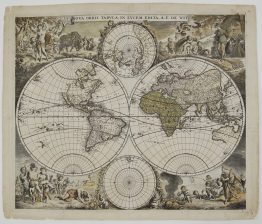
c. 1686 – G. Valck – Mappe Monde
4,500 €
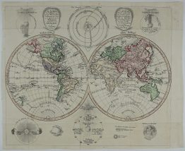
Title: “Mappe-Monde Geo-Hydrographique, ou Description Generale du Globe Terrestre et Aquatique en Deux-Plans-Hemispheres, ou sont exactement remarquées en general toutes les parties de la Terre et de l’Eau suivant les relations les plus nouvelles, par G. Valck.”
Description:
A spectacular Baroque double-hemisphere world map, published in Amsterdam around 1686 by Gerard Valck. Valck combined the latest French geography with the decorative tradition of Dutch mapmaking. The cartography follows Hubert Jaillot’s influential world map of 1674, which was based on the work of Nicolas Sanson. Valck surrounded it with four large allegorical scenes of the seasons.
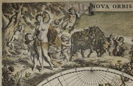
Each season is shown with its seasonal produce and its signs of the zodiac:
- Spring (upper left): garlands and flowers.
- Summer (upper right): Ceres with sickle and sheaves of wheat.
- Autumn (lower left): Bacchus and his followers with grapes.
- Winter (lower right): an old man wrapped against the wind, with winter vegetables at his feet.
In the spaces between the hemispheres, allegorical figures in the clouds represent the continents. Two smaller polar projections, of the North and South Poles, sit above and below the main hemispheres. According to Barry Ruderman, the seasons scenes appear here for the first time. Valck later reused them on his other world maps, including his eight-sheet wall map.
The geography shows the world as it was understood in the 1680s:
- America: California is drawn as an island. The Great Lakes follow French sources, the north-west coast is largely blank and Labrador is named “Estotiland”. In South America the map shows the mythical Lake Parime, linked to the legend of El Dorado, and Lake Xarayes.
- Asia: Korea is a peninsula, and a large “Terre de Iesso” stretches east from Japan towards America.
- The south: Tasman’s discoveries appear as fragments of New Holland, Van Diemen’s Land and New Zealand. A shrinking “Terre Australe et Inconnue” still hints at the unknown southern continent.
The imprint in the lower left reads “Amsterdam chez Gerard Valck sur le Dam, avec Privilege”.
Gerard Valck (1652–1726) learned engraving in London under Abraham Blooteling before returning to Amsterdam. In 1687 he went into partnership with his brother-in-law Pieter Schenk, and the firm later held a near monopoly on Dutch globe-making for half a century. His maps were sold separately and bound into composite atlases, and this map was still being issued unchanged in his atlas as late as 1711.
Cartographer: Gerard Valck (1652 – 1726)
Sheet size: 53,0 x 61,2 cm
Year: c. 1686
Technique: copper engraving
Reference: Shirley, The Mapping of the World, no. 531
Condition:
Good. Contemporary hand colouring. Lower margin extended, with a few small restorations. Verso backed with Japanese tissue.
This is an original antique map published circa 1686 and NOT a modern copy or reprint
On your request we will provide a Certificate of Authenticity
In stock