c. 1572 – G. Braun & F. Hogenberg – Paris
2,200 €
Title: “Lutetia, vulgari nomine Paris, urbs Galliae maxima, Sequana navigabili flumine irrigatur…”
(Lutetia, commonly called Paris, the greatest city of France, watered by the navigable river Seine…)
Description:
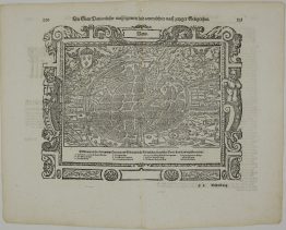
One of the earliest printed plans of Paris, from the first volume of the Civitates Orbis Terrarum by Georg Braun and Franz Hogenberg. The Civitates was the first great atlas of town plans and views.
The city is shown from above, with east at the top. The Seine flows down through the centre around the Île de la Cité, with Notre-Dame and the Sainte-Chapelle. On either side, the river is lined with the University quarter, on the Left Bank, and the Town, on the Right Bank, both enclosed by the medieval walls. The Bastille guards the eastern gate, and fields, gardens, windmills and the outlying villages surround the city.
In the upper left, the arms of Paris, a ship beneath fleurs-de-lis, crown the Latin title cartouche. In the lower right is a French poem in praise of the city, beginning “Paris pour vray est la maison royalle”. In the lower left, a gentleman greets two ladies dressed in the fashions of the 1560s.
The plan goes back to the lost “Premier Plan” of Paris, a huge manuscript plan made around 1530. Sebastian Münster also used it for his view of Paris in the Cosmographia.
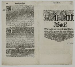
On the back is Georg Braun’s Latin description of the city, which includes some memorable details:
- The crocodile: a crocodile was once found alive in the foundations of the royal palace, and its skin “is still shown today in the great hall”.
- The St Bartholomew’s Day massacre: “on 24 August 1572 the greatest slaughter of the Huguenots was committed in this city, such as no history has recorded since the destruction of Jerusalem”.
Georg Braun (1541–1622), a canon of Cologne, edited the work and wrote the texts, and Franz Hogenberg (1535–1590) engraved most of the plates. The six volumes appeared between 1572 and 1617 and contain more than 500 plans and views.
Cartographer: Georg Braun (1541 – 1622) & Franz Hogenberg (1535 – 1590)
Sheet size: 54,3 x 40,2 cm
Year: c. 1572
Technique: copper engraving
References: Van der Krogt 4, 3298; Boutier 15
Condition:
Good condition. Attractive hand coloring.
This is a genuine antique map published circa 1572 and NOT a modern copy or reprint
On your request I will provide a Certificate of Authenticity
In stock