- View cart You cannot add another "1796 - D. F. Sotzmann - Polen Litauen und Kurland" to your cart.


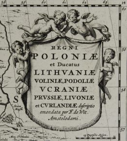
1688 – F. de Wit – Regni Poloniae et Ducatus Lithuaniae
800 €
Title: ” Regni Poloniae et Ducatus Lithuaniae, Voliniae, Podoliae, Ucraniae, Prussiae, Livoniae et Curlandiae Descriptio ”
Description:
The map of Lithuania, Latvia, Poland, Prussia, Estonia, Belarus, Ukraine and Russia, sixth edition.
Comes from by Frederick de Wit “Atlas Maior” published in Amsterdam 1688.
Cartographer: Frederick de Wit (1630 – 1706)
Sheet size: 60,8 x 51,5 cm
Year: 1688
Technique: copper engraving
Condition:
Good condition, wide margins. Lower centerfold separation restored. Contemporary coloring.
This is an original antique map published in 1688 and NOT a modern copy or reprint
On your request I will provide a Certificate of Authenticity
In stock