1693 – N. de Fer – Charle-Roy
30 €
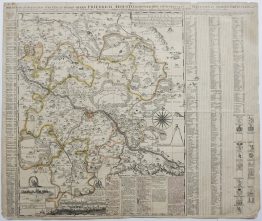
Title: “CHARLE ROY, Ville forte des Pays Bas dans le Comte de Namur…”
Description:
Very decorative plan of the fortified city of Charleroi (historically spelled Charle-Roy), Belgium. The plan depicts the city as a major fortified stronghold on the Sambre River. The city is shown with its characteristic star-shaped bastions and complex outer defensive works. The top left features a cartouche with a distance scale labeled “Eschelle de 100 Toises,” while the bottom left contains a historical description of the city.
The engraving comes from the Nicolas de Fer atlas “Les Forces de l’Europe, ou Description des principales villes, avec leurs fortifications.” engraved by Herman van Loon, published in Paris, 1693.
Cartographer: Nicolas de Fer (1646 – 1720)
Sheet size: 34,0 x 29,7 cm
Year: 1693
Technique: copper engraving
Condition:
Good, original condition.
This is an original antique map published in 1693 and NOT a modern copy or reprint
On your request I will provide a Certificate of Authenticity
In stock