

c. 1730 – M. Seutter – Borussiae Regnum
300 €
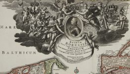
Title: “Borussiae Regnum…Friderici Wilhelmi…”
Description:
Gorgeous map of the Prussia, the Baltic region, extends from Memel (Klaipeda) to Pomerania, centered on Dantzig and Konigsberg. Large decorative cartouche centered on a portrait of Frederick William the King of Prussia. He was also the sovereign prince of the Principality of Neufchatel in Western Switzerland, the inset map of the region present too.
Comes from M. Seutter atlas “Atlas Novus sive Tabulae geographicae totius Orbis Faciem, Partes, Imperia, Regna et Provincias exhibentes” published in Augsburg, circa 1730.
Cartographer: Matthaeus Seutter (1678-1757)
Leaf size: 52,3 x 61,9 cm
Year: c. 1730
Technique: copper engraving
Condition:
Very good condition. Original hand coloring.
This is an original antique map published circa 1730 and not a modern copy or reprint
On your request I will provide a Certificate of Authenticity
In stock


")


