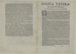
1564 – G. Ruscelli – Polonia et Hungaria
180 €
Title: “Polonia et Hungaria Nuova Tavola”
Description:
The Ruscelli’s map showing Poland, Hungary, Romania, Moldavia and Slovakia.
Comes from atlas “La geografia di Claudio Tolomeo Alessandrino, nuouamente tradotta di Greco in Italiano, da Girolamo Ruscelli” published by G. Zileti in Venice 1564.
Cartographer: Girolamo Ruscelli (1504 – 1566)
Sheet size: 32,2 x 23,4 cm
Year: 1564
Technique: copper engraving
Condition:
Very good condition! Watermarked paper. Middlefold professionally cleaned and few wormholes restored.
This is an original antique map published in 1564 and NOT a modern copy or reprint
On your request I will provide a Certificate of Authenticity
In stock