- View cart You cannot add another "1612 - A. Ortelius - Asiae Nova" to your cart.


1640 – W. J. BLAEU – China Veteribus Sinarum
1,300 €
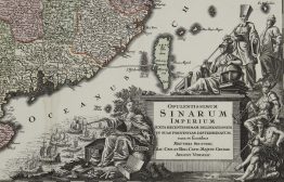
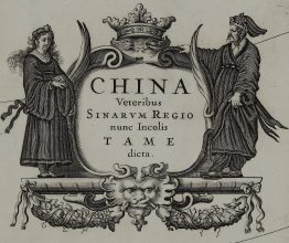
Title: “China Veteribus Sinarum Regio nunc Incolis Tame dicta.”
Description:
Very attractive map of China, Japan and Korea, the first of Blaeu’s maps of China. The map includes the eastern part of China (the Great Wall forms the northern boundary of China). Korea is depicted as a strangely shaped island. Taiwan is located in a roughly correct position, named as both Pakan al I. Formosa and Tayoan. The three main islands of Japan are shown on the Ortelius/Teixeira model. The fictitious Chiamay Lacus is shown with numerous rivers flowing south into India and Siam. Two Dutch merchant ships and two Chinese junks are showed too. The map includes an attractive cartouche with Chinese woman & man and coat of arms with dedication to Theodore Bas, director of the Dutch East Indian Company.
The map comes from the 2nd French edition of Blaeu’s atlas ” Le Theatre du Monde ou Nouvel Atlas” published in Amsterdam, 1640.
Cartographer: Willem Janszoon Blaeu (1570 – 1630)
Sheet size: 58,9 x 50,4 cm
Year: 1640
Technique: copper engraving
Condition:
Very good, original condition. Contemporary hand coloring. Few small marginal splits present.
This is a genuine antique map published in 1640 and NOT a modern copy or reprint
On your request I will provide a Certificate of Authenticity
In stock