- View cart You cannot add another "c. 1730 - M. Seutter - Opulentissimum Sinarum Imperium" to your cart.


1662 – F. de Wit – Tabula Indiae orientalis
900 €
Title: “Tabula Indiae orientalis.”
Description:
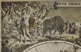
Detailed map of East Indies, the first of three maps of the East Indies that de Wit produced. It extending from Persia to northern Australia including the Philippine archipelago, Borneo (Celebes), Southern China and Taiwan (Formosa). Northern Australia (Hollandia Nova) is shown with the names ‘Van Diemens Landt’, ‘Baya van Diemen’ and ‘Vuyle hoeck’. Most of geographical information arrived from the missionary efforts of the Jesuits and from the English East India Company. Attractive title cartouche top right surrounded by turbaned warriors and native figures.
The map comes from Frederick de Wit atlas “Atlas sive description Terrarum Orbis…” engraved by Johannes Lhuilier, published in Amsterdam, 1662.
Cartographer: Frederick de Wit (1630 – 1706)
Sheet size: 49,5 x 58,8 cm
Year: 1662
Technique: copper engraving
Condition:
Good, original condition, no restorations. Contemporary colouring. Paper very slightly age toned, small tears on margins.
This is an original antique map published in 1662 and NOT a modern copy or reprint
On your request we will provide a Certificate of Authenticity.
In stock