1712 – J. B. Homann – Saxoniae Inferioris
150 €
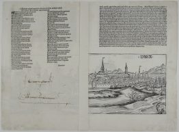
Title: “Circulus Saxoniae Inferioris in omnes suos Status et Principatus…”
Description:
Highly detailed map of the northern part of Germany showing the area between Kiel, Rügen, Berlin, Halle and Oldenburg. The map is adorned with beautiful title-cartouche and small view of Hamburg.
The map comes from the Johann Baptist Homann atlas “Atlas Novus Terrarum Orbis Imperia…“ published in Nuremberg 1712.
Cartographer: Johann Baptist Homann (1664-1724)
Sheet size: 51,5 x 60,5 cm
Year: 1712
Technique: copper engraving
Condition:
Good condition. Original contemporary colors, strong press and on watermarked paper. Lower center fold reinforced on verso.
This is an original antique map published in 1712 and NOT a modern copy or reprint
On your request I will provide a Certificate of Authenticity
In stock