1719 – H. A. Chatelain – Plan de Venise
850 €
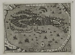
Titles: “Carte du Plan de Venise, L’Etat de sa Noblesse, et ses Differens Digrez, avec quelques autres . . .”
Description:
Attractive bird’s eye view of Venice (Venetia) by Henri Abraham Chatelain. It shows the important buildings, sailing ships and descriptions.
The sheet comes from Henri Abraham Chatelain atlas “Atlas Historique ou Nouvelle introduction…” published in Amsterdam 1719.
Publisher: Henri Abraham Chatelain (1684-1743)
Sheet size: 53,3 x 45,5 cm
Year: 1719
Technique: copper engraving
Condition:
Very good condition.
This is an original antique map published in 1719 and NOT a modern copy or reprint
On your request I will provide a Certificate of Authenticity
In stock