- View cart You cannot add another "1914 - E. Muller - Europe" to your cart.

1720 – H. Chatelain – Nouvelle carte Europe
120 €
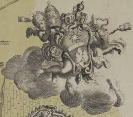
Titles: “Nouvelle carte des conciles generaux et particuliers qui se sont tenus en Europe, en Asie, en Afrique et en Amerique…”
Description:
A decorative map of Europe, describing the places and dates for the General (Eucemenical) and Local (Particular) Councils of the Roman Catholic Church.
The map comes from Henri Abraham Chatelain atlas “Atlas historique, ou nouvelle introduction a l’histoire , à la chronologie & à la géographie ancienne & moderni…” published in Amsterdam 1720.
Cartographer: Henri Abraham Chatelain (1684-1743)
Sheet size: 59,1 x 52,3 cm
Year: 1720
Technique: copper engraving
Condition:
Good condition. Few small reinforcements on verso.
This is an original antique map published in 1720 and NOT a modern copy or reprint
On your request I will provide a Certificate of Authenticity
In stock