

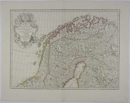
1730 – J. B. Homann – Regni Norvegiae
400 €
Title: “Regni Norvegiae Accurata Tabula in qua Praefecturae Quinque Generales Aggerhusiensis, Bergensis Nidrosiensis, Wardhusiensis et Bahusiensis”
Description:
Very detailed antique map of Norway including an inset with the Lofoten to the North Cape.
The map comes from the Johann Baptist Homann atlas “Atlas Novus Terrarum Orbis Imperia…“ published in Nuremberg 1730.
Cartographer: Johann Baptist Homann (1664-1724)
Sheet size: 51,8 x 60,4 cm
Year: 1730
Technique: copper engraving
Condition:
Good condition. Contemporary hand coloring. Narrow left margin.
This is an original antique map published in 1730 and NOT a modern copy or reprint
On your request I will provide a Certificate of Authenticity
In stock


")


