1733 – A. Desing – Historica Auxilia
Title: “Historica Auxilia. Historischer Behülff und Unterricht von der Geographia, Politica, Chronologia, Kriegs-Weesen, und anderen nach heutiger Art meistens zur Histori zu wissenden Dingen. Für die Catholische Jugend. Tl. I ”
Description:
Complete miniature book/atlas, Part 1 (of 3), 1st edition, issued by Anselm Desing in Sulzbach 1733.
The following maps are included:
-World Map
-Europe continent – 2 maps
-Asia continent – 2 maps
-Africa continent
-Western hemisphere – 2 maps
-Spain, Portugal
-Italy
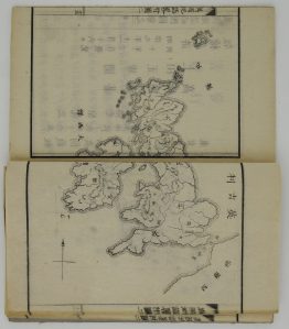
-Great Britain, Ireland
-France
-Germany – 2 maps
-German provinces – 9 maps
-Bohemia
-Austria
-Netherlands
-Switzerland
-Scandinavia
-Russia
-Poland
-Hungary, Balkans
-Greece, Turkey
-Middle East
Cartographer: Anselm Desing (1699 – 1772)
Atlas size: 9,6 cm x 6 cm x 1 cm
Year: 1733
Technique: copper engraving
Condition:
Good condition! Cover slightly browned, some stains.
This is an original antique atlas published in 1733 and not a modern copy or reprint.
On your request I will provide a Certificate of Authenticity