c. 1593 – G. Braun & F. Hogenberg – Constantinopolis
1,700 €
Title: “Byzantium nunc Constantinopolis”
(Byzantium, now Constantinople)
Description:
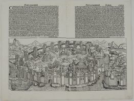
One of the finest and most sought-after early views of Istanbul, from the first volume of Georg Braun and Franz Hogenberg’s Civitates Orbis Terrarum, the first great atlas of town views.
The city is seen from Scutari (Üsküdar), across the Bosphorus on the Asian shore. Its walls and towers enclose the whole peninsula, and Pera and Galata lie across the Golden Horn on the right. The Italian labels name the landmarks:
- The Seraglio: “Seraglio novo dove sta el gran Turcho”, the new palace of the Sultan, now Topkapı, on the point.
- Monuments: Hagia Sophia and the Hippodrome.
- The Seven Towers: “Castel novo dove sta el tesoro del gran Turcho”, the castle where the Sultan’s treasury was kept, now Yedikule.
- The Palace of Constantine: the Tekfur Palace by the land walls.
- The water: the arsenal, the galley harbour and the Princes’ Islands. A small tower in the water at the lower right is labelled as the place “where the Turks keep guard over passengers”.
European galleons and Turkish galleys fill the Bosphorus and the Golden Horn.
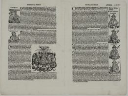
In the foreground, a sultan on horseback rides with his janissaries. Some scholars identify him as Suleiman the Magnificent. On either side are roundel portraits of twelve Ottoman sultans, from Osman, founder of the dynasty around 1300, through Mehmed II, the conqueror of Constantinople, and Suleiman, to Murad III, who came to the throne in 1574.
The view belongs to a family of images that goes back to Giovanni Andrea Vavassore’s woodcut, published in Venice around 1520, which explains its Italian place names. Braun and Hogenberg improved on Vavassore in many places, most of all in the Hippodrome.
On the back is Georg Braun’s Latin description of the city, which includes some memorable details:
- Names: the city is called “Stimboli” by the Greeks and “Stambol” by the Turks.
- Fish: fish are so plentiful that women catch them from their windows with baskets lowered on cords.
- The conquest: Mehmed II took the city on 29 May 1453.
- The portraits: Braun explains that the sultans’ faces are copied “as they are accurately engraved in Venice”, and that the list of Ottoman rulers comes from Adolph Werner’s history of the Turks.
There are four states. In the first, of 1572, the last roundel on the right is blank. The second adds the portrait of Murad III. The third adds the privilege, “Cum Privilegio”. Jansson later printed a fourth state without the portraits. This example is the third state, with Murad III and the privilege.
Cartographer: Georg Braun (1541 – 1622) & Franz Hogenberg (1535 – 1590)
Sheet size: 53,6 x 39,8 cm
Year: c. 1593–1599 (third state)
Technique: copper engraving
Condition:
Very good. Uncoloured, with a strong impression. Centrefold as issued. Light marginal soiling.
This is an original antique map published circa 1593–1599 and NOT a modern copy or reprint
On your request I will provide a Certificate of Authenticity
In stock