1921 – P. Langhans – Das Litauische Sprachgebiet in Ostpreusen
50 €
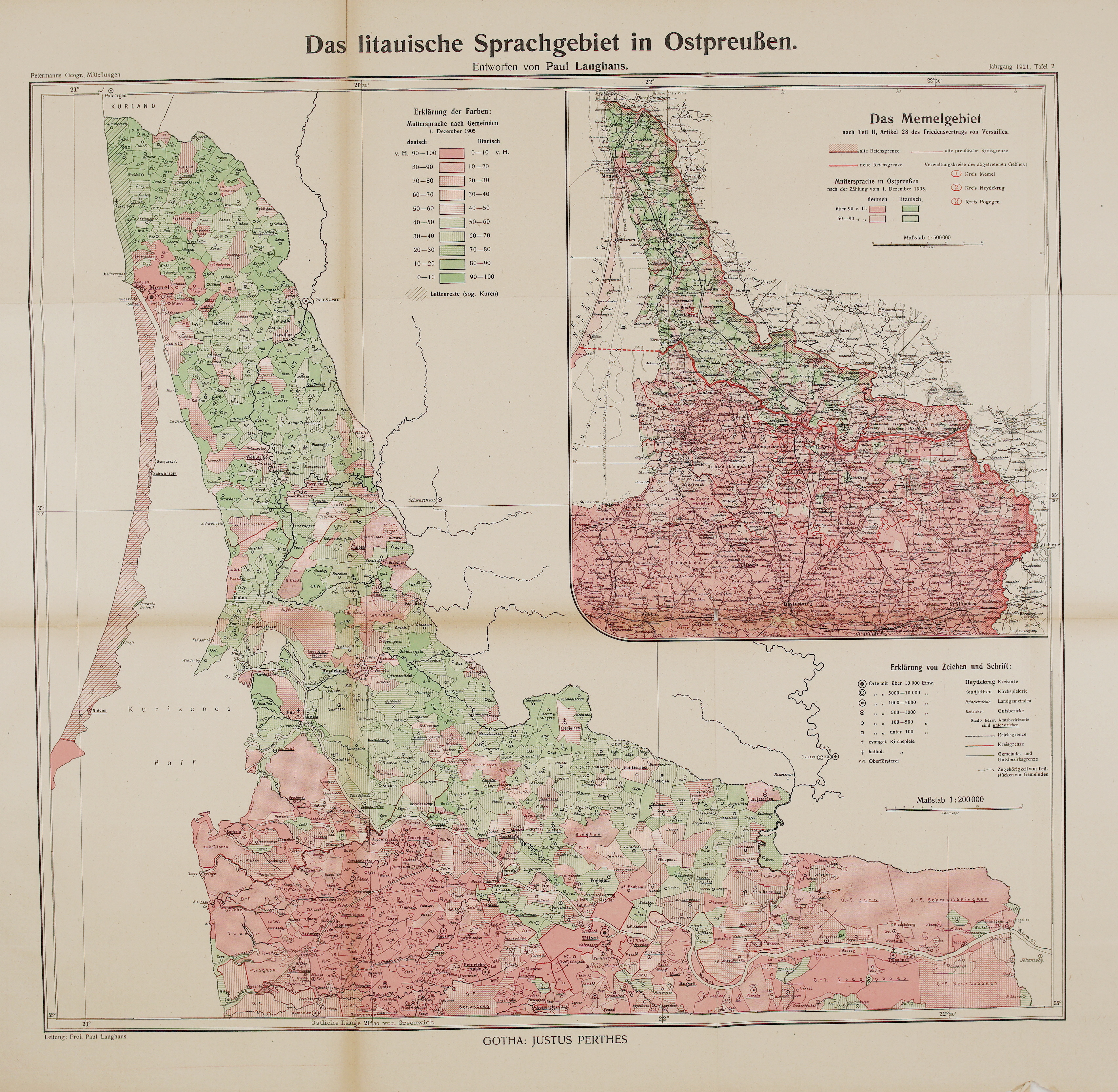
Title: “Das litauische Sprachgebiet in Ostpreußen. Entworfen von Paul Langhans.”
&
“Das Memelgebiet nach Teil II, Artikel 28 des Friedensvertrags von Versailles.”
Description:
A detailed language map of Lithuania Minor (Mažoji Lietuva), the Lithuanian-speaking north-east of East Prussia. It was drawn by Paul Langhans and published by Justus Perthes in Gotha as plate 2 of Petermanns Geographische Mitteilungen for 1921.
The map shows the mother tongue of the people in every municipality and estate district (“Muttersprache nach Gemeinden”), based on the Prussian census of 1 December 1905. Each municipality is coloured in ten steps of 10 per cent, from red (German) to green (Lithuanian), so the map can be read almost village by village. A separate hatching marks the “Lettenreste (sog. Kuren)”: the Curonians (kuršininkai) of the Curonian Spit and the coast north of Klaipėda, fishermen who spoke a Latvian dialect.
- Main map, scale 1:200,000: from Palanga (Polangen) and the Courland border in the north to 55° N in the south, and from the Curonian Spit to the Russian border at Gargždai (Garsden) and Tauragė (Tauroggen). It shows Memel (Klaipėda), Prökuls (Priekulė), Heydekrug (Šilutė), Ruß (Rusnė), Kinten (Kintai), Windenburg (Ventė), Nidden (Nida), Schwarzort (Juodkrantė), Pogegen (Pagėgiai), Coadjuthen (Katyčiai), Willkischken (Vilkyškiai), Wischwill (Viešvilė) and Schmalleningken (Smalininkai). South of the Memel river it shows Tilsit (Tilžė, today Sovetsk) and Ragnit (Ragainė, today Neman). The legend marks towns by number of inhabitants, district towns, parish villages, Protestant and Catholic parishes, forestry offices, and the borders of the Reich, the districts and the municipalities.
- Inset “Das Memelgebiet”, scale 1:500,000: the territory north of the Memel river that Germany had to give up under the Treaty of Versailles. It shows the old and the new border of the Reich, the new border running along the Memel (Nemunas) and across the Curonian Lagoon and Spit south of Nida, and the three districts of the ceded territory: Memel, Heydekrug and Pogegen. The inset also shows the languages of 1905 in a wider part of East Prussia, from Labiau, Wehlau and Insterburg to Gumbinnen, Pillkallen and Stallupönen.
The map was made at a turning point for the region. Under the Treaty of Versailles, in force from 10 January 1920, the Memel Territory (Klaipėda Region) was separated from Germany and placed under the Allied Powers, with a French administration in Klaipėda. Its future was still open when this map appeared; in January 1923 the territory was taken over by Lithuania. Paul Langhans (1867–1952), a leading cartographer at Justus Perthes and editor of Petermanns Mitteilungen from 1909 to 1937, specialised among other things in maps of languages and nationalities, and the map belongs to the German side of the debate over the region in those years. Today it is an important source on the Lithuanian population of Lithuania Minor before the First World War.
It is rare on the market.
Cartographer: Paul Langhans (1867 – 1952)
Publisher, Place: Justus Perthes, Gotha
Sheet size: 62,0 x 60,7 cm
Year: 1921
Technique: colour lithograph
Condition:
Good condition. Folded as issued. Bright original colours and clear printing. Light toning and a few small spots. A few marginal splits present.
This is an original antique map published in 1921 and NOT a modern copy or reprint
On your request I will provide a Certificate of Authenticity
In stock