1665 – A. Kircher – Asiae Majoris
1,000 €
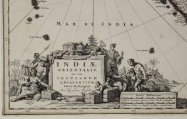
Title: “Tabula Geographica Hydrophylacium Asiae Majoris exhibens, quo Omnia Flumina sive proximè sive remotè per occultos meandros Originem suam sortiuntur.”
Description:
One of the earliest thematic maps of Southeast Asia, illustrating the theories of the Jesuit scholar Athanasius Kircher, the first edition. The map is centered on India and covers the Arabian Peninsula, Persia and Caspian Sea, China, Cambodia and the Malay peninsula, the Philippine and Indonesian archipelagos. Decorative title cartouche features putties and Neptune.
The map comes from Athanasius Kirchir’s “Mundus Subterraneus, in XII libros digestus, quo divinum subterrestris mundi opificium, mira ergasteriorum naturae in eo distributio …” published by J. Janssonius & Elizeum Weyerstraten in Amsterdam, 1665.
Cartographer: Athanasius Kircher (1602-1680)
Sheet size: 44,6 x 39,1 cm
Year: 1665
Technique: copper engraving
Condition:
Very good, original, condition. Watermarked paper.
This is an original antique map published in 1665 and NOT a modern copy or reprint
On your request we will provide a Certificate of Authenticity.
In stock