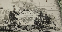
1710 – J. Wolff – Africa
Title: “AFRICA Concinnata Secundum Observationes…”
Description:
Rare issue by German publisher Jeremia Wolff of de l’Isle’s map of Africa which served as the model for European mapmakers and was frequently copied throughout the eighteenth century. Delisle’s last remaining major concession to Ptolemy is with the map’s east to west flow of the Niger River into the Atlantic, though the Niger source lake, Lacus Niger in west central Africa, is not presented as on previous maps of Africa. The west to east Nubia River, also shown in previous maps flowing eastward into the Nile, ceases to exist on this map. Delisle also gives the correct longitude for the Mediterranean Sea of 42°, thus correcting the width of the northern shape of Africa. He shows a vaguely engraved and unidentified lake, at about 5° S, not far inland from Zanzibar in East Africa with no rivers entering or exiting it. The cartouche is beautifully decorated with elephants and an ostrich being hunted by a man on horseback, while a native is wrestling with a crocodile.
Publisher: Jeremias Wolff (1663 – 1724)
Sheet size: 50,5 x 60,5 cm
Plate size: 45,5 x 58,5 cm
Year: 1710
Technique: copper engraving
Condition:
Good condition! Original hand colouring on watermarked paper. Lower middle fold separation and few splits professionally restored.
Due to the age of this map some imperfections to be expected!
This is an original antique map published in 1710 and NOT a modern copy or reprint!
On your request we will provide a Certificate of Authenticity.