1735 – M. Seutter – Episcopatuum Monasteriensis
150 €
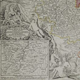
Title: “Episcopatuum Monasteriensis Et Osnabrugensis Ut Et Comitatuum Bentheim, Teclenburg, Stenford, Lingen, Diepholt, Delmenhorst, Rietberg etc. etc. novissima et accuratissima Designatio cura et sumptibus Matthaei Seutteri, S.C. Et Reg. Cathol. Majest. Geogr. Augustae Vindel.”
Description:
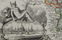
Beautiful map of the region of Münster and Osnabrück, from Emden to Soest and from Bremen to Wesel, Germany. Decorative title cartouche with the coats of arms of Münster and Osnabrück, as well as goddess of the hunt at the top left.
Comes from M. Seutter atlas “Atlas Novus Sive Tabulae Geographicae Totius Orbis Faciem, Partes, Imperia, Regna et Provincias exhibentes” engraved by Tobias Conrad Lotter, published in Augsburg, 1735.
Cartographer: Matthaeus Seutter (1678-1757)
Sheet size: 61,2 x 50,3 cm
Year: 1735
Technique: copper engraving
Condition:
Good condition, strong press on watermarked paper. Hand coloring. 3 wormholes present.
This is an original antique map published in 1735 and NOT a modern copy or reprint
On your request I will provide a Certificate of Authenticity
In stock