c. 1700 – G. Valck – Orbis Terrarum
4,500 €
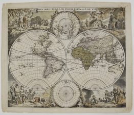
Title: “Orbis Terrarum Nova et Accurata Tabula. Auct. G. et L. Valk”
(A new and accurate map of the world, by G. and L. Valk)
Description:
A magnificent Baroque double-hemisphere world map by Gerard Valk and his son Leonard, published in Amsterdam around 1700. It is the only Valk world map to name Leonard as co-author. The imprint in the lower right reads “t’Amsterdam Gedrukt by Gerard Valck met Privilegie”.
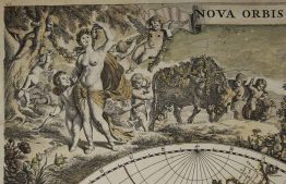
Allegorical scenes of the four seasons surround the hemispheres:
- Spring (upper left): Flora dancing with garlands, while putti draw a flower-decked chariot.
- Summer (upper right): Ceres bringing in the wheat harvest, with a loaded harvest wagon.
- Autumn (lower left): Bacchus with satyrs and putti, gathering grapes and garlanding a herm with vines.
- Winter (lower right): a powerful old man with a staff stands under a bare tree, as the north wind blows and putti tend to fish.
Further allegorical figures fill the spaces between the hemispheres, and circular projections of the North and South Poles sit above and below them. The seasons repeat, in a new engraving, the design Valk first used on his Mappe-Monde of around 1686.
The cartography was updated from Valk’s earlier world maps:
- America: California is drawn as an island, and a conjectural “Mer Glaciale” almost links Hudson Bay with the sea north of California. The newly explored Mississippi basin appears, along with all five Great Lakes and Quebec. Greenland is joined to North America.
- The North Pacific: a vast “Terra Incognita sive Terra Esonis” stretches across it towards Asia.
- The south: Australia is shown without its east coast and almost touching New Guinea. Van Diemen’s Land and New Zealand appear only in part, and the imaginary southern continent has been removed.
A Latin note in the South Pole inset explains that longitudes are counted from Tenerife in the Canary Islands, to match the Valks’ own new terrestrial globes.
Gerard Valk (1652–1726) learned engraving in London before returning to Amsterdam, where his firm became the leading Dutch maker of globes. His son Leonard (1675–1746) joined him in the business and carried it on after his death.
Cartographer: Gerard Valk (1652–1726) and Leonard Valk (1675–1746)
Sheet size: 52,4 x 61,2 cm
Year: c. 1700
Technique: copper engraving
Reference: Shirley, The Mapping of the World, no. 638
Condition:
Good, original condition. Contemporary colour. A few marginal splits and small spots. Centrefold reinforced on verso. Old inventory number in ink in the lower margin.
This is an original antique map published circa 1700 and NOT a modern copy or reprint
On your request we will provide a Certificate of Authenticity
In stock