- View cart You cannot add another "1631 - W. J. Blaeu - Magni Ducatus Lithuaniae" to your cart.

c. 1700 – G. Valck – Orbis Terrarum
4,500 €
Title: “Orbis Terrarum Nova Et Accurata Tabula. Auct. G. et L. Valk”
Description:
This is a rare and magnificent double hemisphere world map. The map is based on Frederik de Wit’s world map executed map from 1670-1680. It also shares inspiration from Jaillot’s map Mappe-Monde of 1674. This is the last of Valk’s world maps and the only one with the imprint of his son, Leonhard Valk.
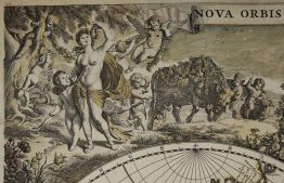
Shirley notes: “The map has been updated geographicaly compared to Valk’s earlier ones and now includes the newly-discovered Mississippi basin and the supposed Mer Glaciale almost connecting Hudson’s Bay with the ocean just north of California. All traces of any southern continent have been deleted…” California is depicted as an island as well. The map shows Greenland as connected to North America. All five Great Lakes are present and Quebec is noted. It shows part of Australia as connected to New Guinea and only part of the New Zealand coastline is present.
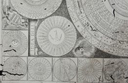
The hemispheres are surrounded by allegorical scenes of the four seasons done in the Baroque style. Shirley describes it as “joyous Spring, industrious Summer, bucolic Autumn, and icy Winter.” Between the hemispheres, there are two circular projections of the North and South Poles.
The map comes from Gerard and Leonard Valk atlas “Nova totius Geographia…” published in Amsterdam, c. 1700.
Cartographer: Gerard Valck (1652 – 1726)
Sheet size: 52,4 x 61,2 cm
Year: c. 1700
Technique: copper engraving
Condition:
Good, original condition. Contemporary coloring. Few marginal splits present. Middle fold reinforcement on verso.
This is an original antique map published circa 1700 and NOT a modern copy or reprint
On your request we will provide a Certificate of Authenticity
In stock