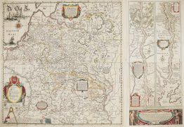
1593 – C. De Jode – Poloniae Amplissimi
6,500 €
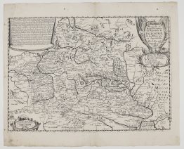
Title: “Poloniӕ Amplissimi Regni .. Typvs Geographicvs”
Description:
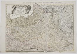
A rare, early and finely engraved map of the Polish-Lithuanian Commonwealth, from the 1593 second edition of the de Jode atlas, Speculum Orbis Terrae. The plate was engraved by Gerard de Jode and published after his death by his son Cornelis. Polish map historians count it among the most beautiful engraved maps of Poland of the 16th century.
The map covers the Commonwealth from Pomerania and the Oder in the west to Borisov and Volhynia in the east, and from Samogitia and the Neman down to the Carpathians. The Grand Duchy of Lithuania is named across the top right, with Vilnius, Trakai, Kaunas, Grodno, Brest and Pinsk marked, and Podlasie carries its own label, “Litvania Ducatus”. Prussia and the Baltic coast, with the Hel Peninsula and the Vistula Spit, follow Caspar Henneberger’s new survey of 1576. Forests are drawn as clusters of trees and mountains as small hills. On the Pomeranian coast the map even marks Wineta, the legendary sunken city of the Baltic.
In the lower left is a portrait of King Sigismund III Vasa (1566–1632) in armour, holding a sceptre. The plate was first issued with a portrait of King Stefan Batory dated 1576. After Batory’s death the copper was burnished and re-engraved with the new king, and faint traces of Batory’s likeness remain beneath Sigismund’s. The inscription, with the engraver’s spelling “Sigusmun”, still calls him only “next heir of the King of Sweden”. That title was already out of date when the atlas appeared, because Sigismund succeeded his father as King of Sweden in November 1592.
The title cartouche in the upper left is flanked by two winged sirens and sits above “Balticum Mare” and a compass rose.
The verso carries Latin text headed “Poloniae Regnum”, with page number “Fol. 10” and signature “Ll”. It describes Poland’s regions and rivers, its honey and wax, and the famous salt mines of Bochnia and Wieliczka. The page number and signature identify this as the 1593 edition.
Published in Antwerp in 1593 “sumptibus Viduae et Heredum Gerardi de Iudaeis”, at the expense of Gerard de Jode’s widow and heirs, and printed by Arnold Coninx.
Gerard de Jode planned his atlas as a direct rival to Abraham Ortelius’s Theatrum Orbis Terrarum of 1570. Ortelius used his influential connections to delay de Jode’s publishing privilege for years, so the first edition only appeared in 1578. Gerard died in 1591, and Cornelis completed the expanded second edition in 1593. Neither edition sold well. When Cornelis died in 1600, the copper plates were bought by Joan Baptista Vrients, the publisher of Ortelius’s atlas, and the Speculum was never printed again. De Jode maps are therefore far scarcer than their Ortelius counterparts.
Cartographer: Gerard de Jode (c. 1509–1591)
Publisher: Cornelis de Jode (1568–1600)
Frame size: 55,1 x 40,8 cm
Year: 1593 (second state; first state with portrait of Stefan Batory)
Technique: copper engraving
References: Kret, Katalog dawnych map Rzeczypospolitej Polskiej, no. 61; Imago Poloniae II, K 74/2
Condition:
Very good, original condition. Uncoloured. Watermarked paper with wide margins. Centrefold as issued. Latin text on verso.
This is an original antique map published in 1593 and NOT a modern copy or reprint.
On your request I will provide a Certificate of Authenticity
In stock